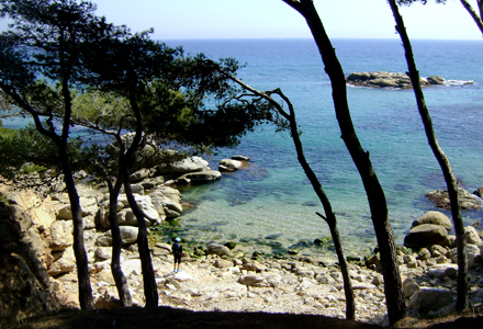
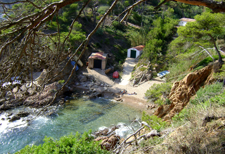
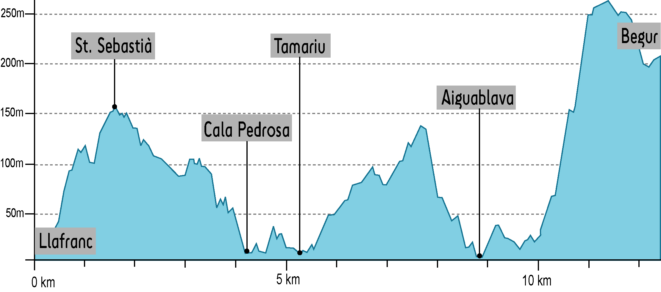
43kmCIRCULAR ROUTEGIRONA - COSTA BRAVA - GIRONA

    • DISTANCE

      140.0 Km

    • ELEVATION +

      3877 m

    • EFFECTIVE TIME

      36h 49 min

    • APPROXIMATE TIME

      43 h 48 min

    CIRCULAR 8 DAYS
    CIRCULAR 8 DAYS
    CIRCULAR 8 DAYS
    Camera

    Cala Canyers - 

    CIRCULAR 8 DAYS
    CIRCULAR 8 DAYS
    CIRCULAR 8 DAYS
    CIRCULAR 8 DAYS

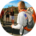
    Walk 140km in eight days (an average of 17,3km per day). Suitable for anyone who is used to hiking and with a medium to high physical condition (8 DAYS, 7 NIGHTS).


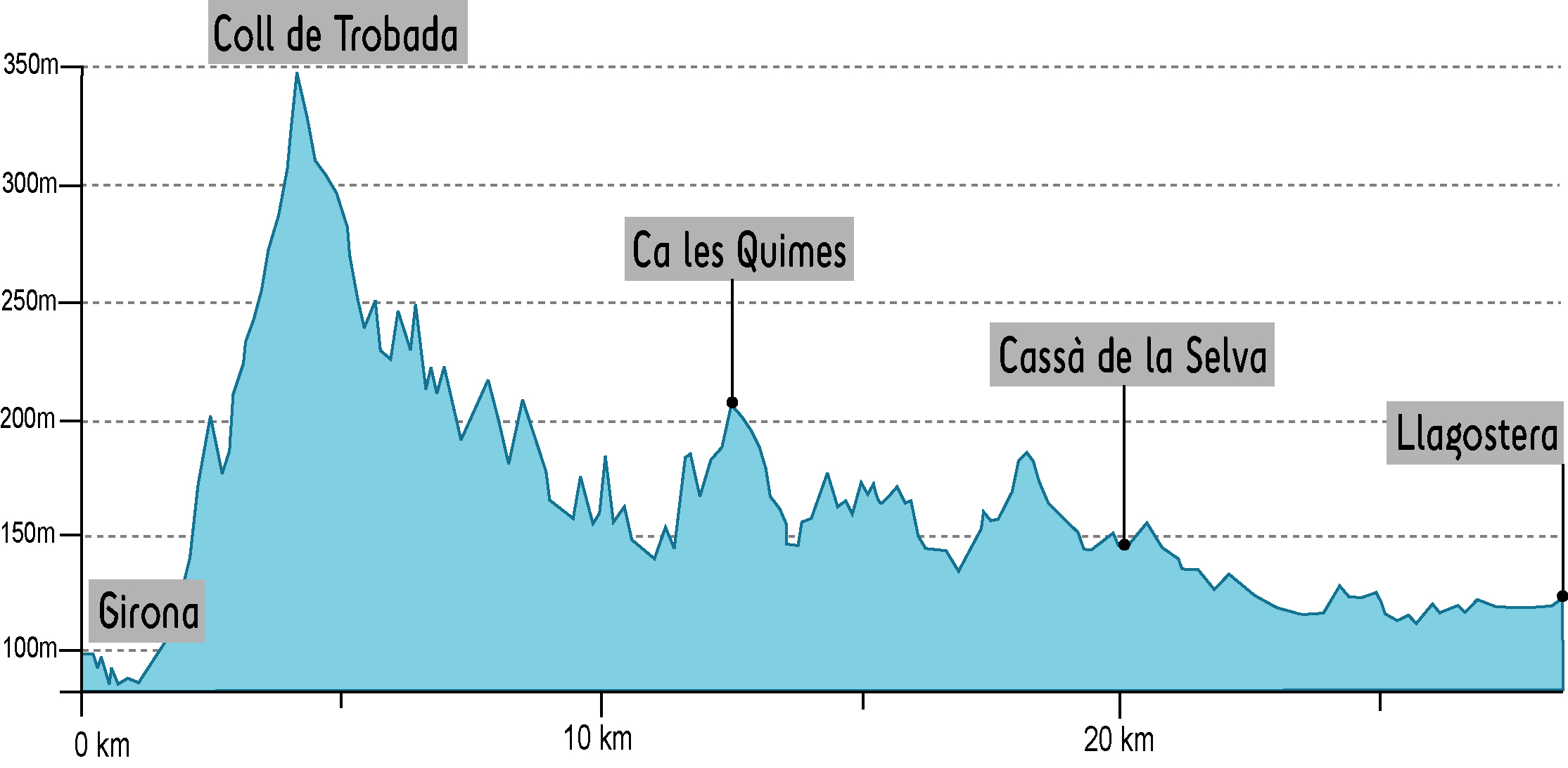
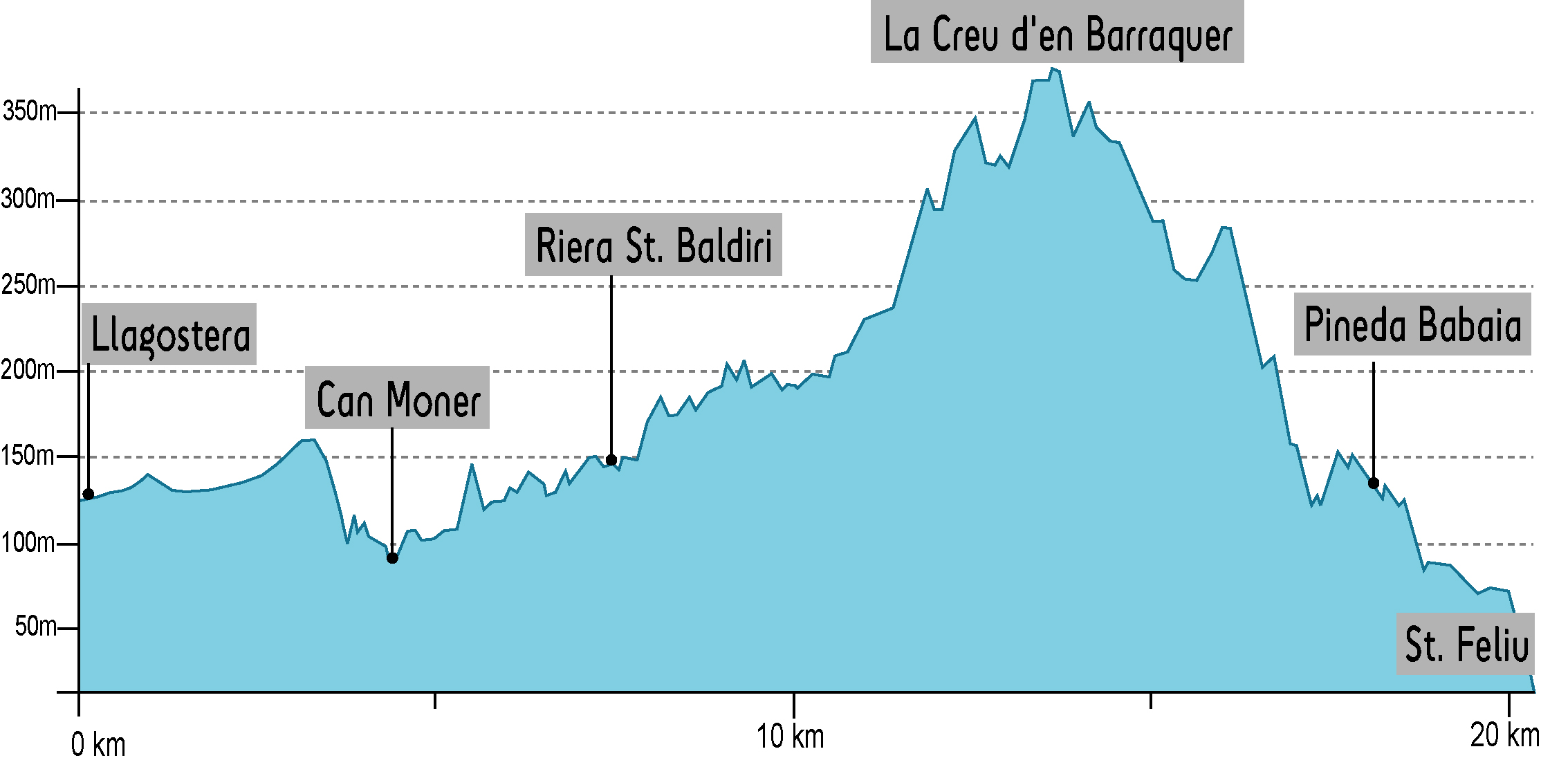
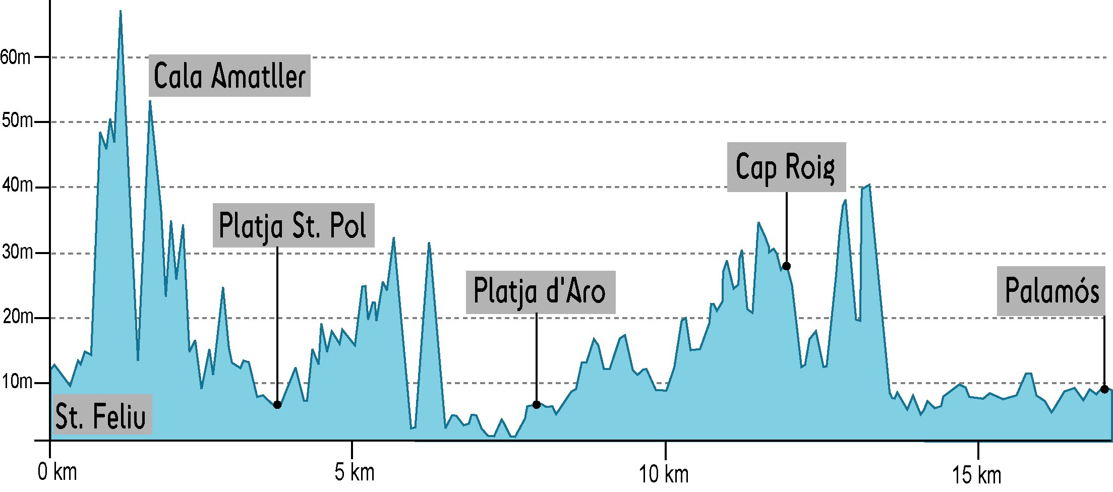
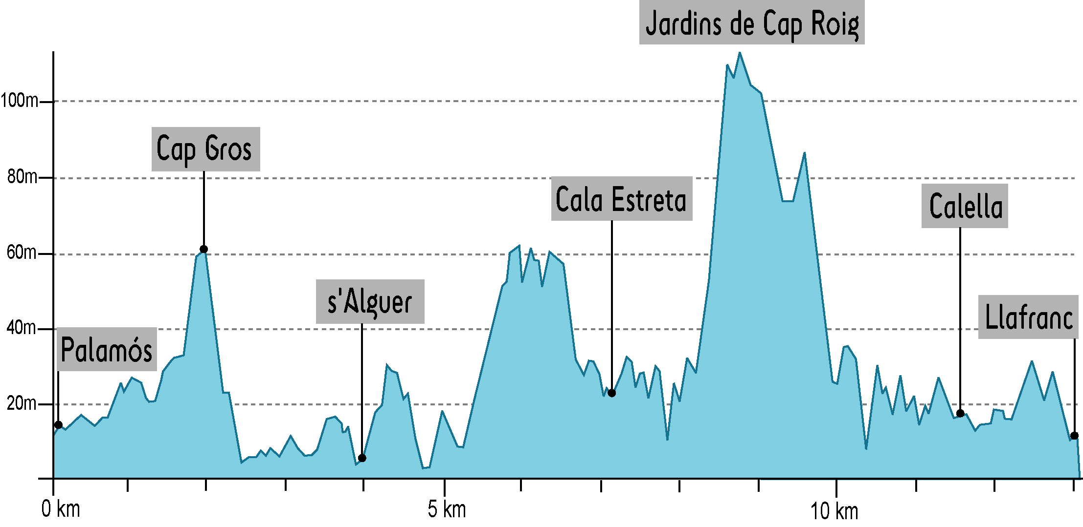
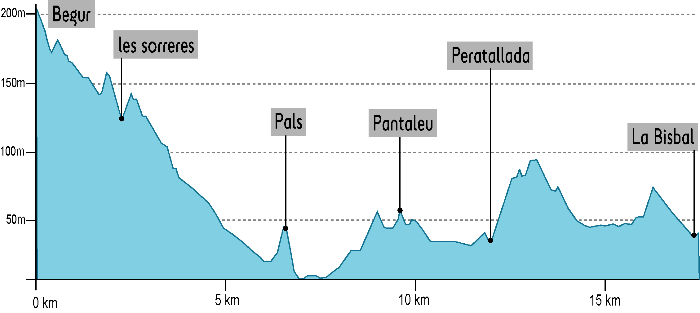
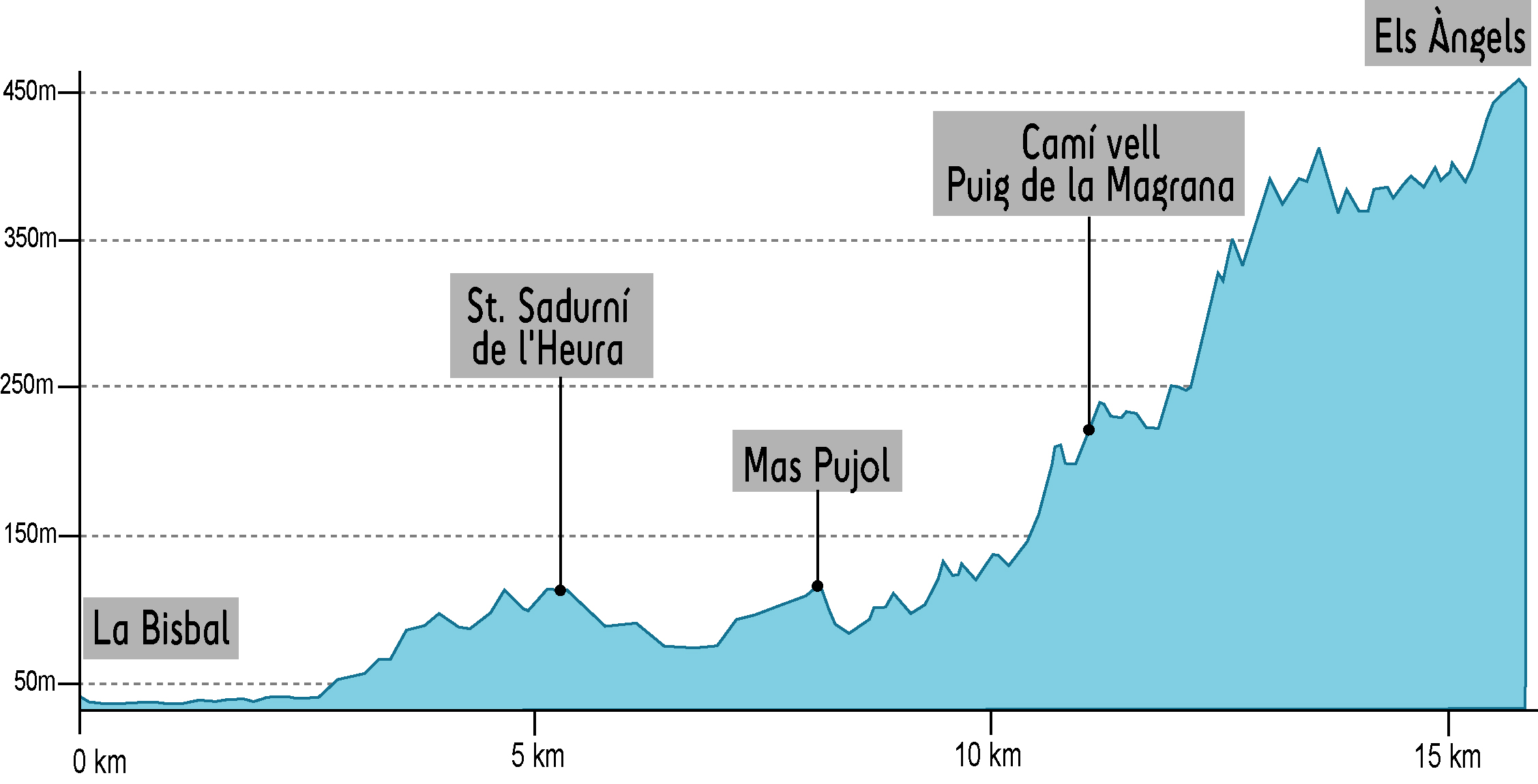
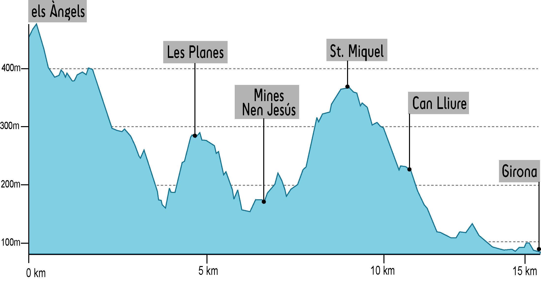
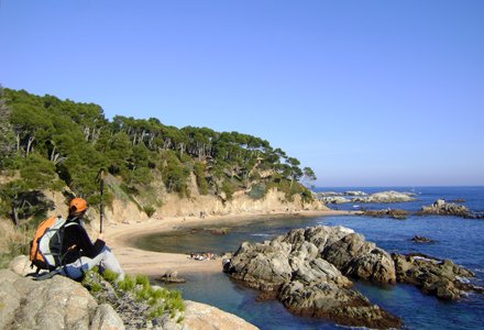
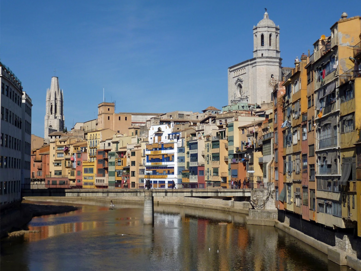
    Starting at the city of Girona, this is the first circular route to do on foot, leading you to the Costa Brava and Camí de Ronda®. It goes through the mounts of les Gavarres, l’Ardenya, the litoral of the Costa Brava and goes back to Girona though the Empordanet flat and the mount of Santuari dels Àngels. It has been especially designed to discover the charms of a route in stages, a route of outstanding contrasts between sea, mountain, and abrupt cliffs of the Costa Brava, while enabling to discover historic ways, medieval villages, paradise beaches of Empordà and the marvelous city of Girona. The last night, with an overnight stay at muntanya dels Àngels will enable us to behold the excellent scenery of nearly all the journey done. 80% of the route takes place in natural protected areas.

  • DAY 1: Girona-Llagostera

    DISTANCE
    28.7 Km
    ELEVATION +
    695 m
    EFFECTIVE TIME
    7 h 33 min
    APPROXIMATE TIME
    8 h 58 min

    Soft mountain and pleasant stage. The start is in the Girona catedral and, after an urban stretch of historical interest, we will go through Sant Daniel valley until we reach the ancient way of Santuari dels Àngels. At this point, the views of Girona are breathtaking. From now on, walking in narrow gloomy ways and paths, we deepen into massís de les Gavarres up to Cassà de la Selva. We will cross the village thought the center and then will continue though the ancient railway converted into a ludic path until we reach Llagostera. 

  • DAY 2: Llagostera - St. Feliu de Guíxols

    DISTANCE
    20.7 Km
    ELEVATION +
    589 m
    EFFECTIVE TIME
    5 h 28 min
    APPROXIMATE TIME
    6 h 29 min

    Stage of slight slopes that will guide us through massís de l’Ardenya. As we leave Llagostera, we enter an area of woods full of riverside plants and, then, walking through gloomy paths and forest roads, we will reach the old church of Sant Baldiri. From this point, with an horizon view of the Mediterranean as a rear view, we will descend amongst rocky castles to Sant Feliu de Guíxols. Just before ending the stage, it is advisable to climb to the Ermita de Sant Elm, viewpoint of the Costa Brava, where it got his name. 

  • DAY 3: St. Feliu de Guíxols - Palamós

    DISTANCE
    17.4 Km
    ELEVATION +
    227 m
    EFFECTIVE TIME
    4 h 30 min
    APPROXIMATE TIME
    5 h 25 min

    We leave the village of Sant Feliu de Guíxols and surrounding the coast we go through cala del Molí, cala Maset and Sant Pol beach. Following, we will find S’Agaró, where Camí de Ronda® became a planned novocentist promenade, designed by architect Rafel Masó in 1916. The route continues to Sa Conca beach and then surrounding the mouth of Ridaura river, we reach the village of Platja d’Aro. We go through this village along the promenade towards Sant Antoni de Calonge. The next stretch is impressive, since Camí de Ronda® becomes a narrow path that twists between cliffs, crystal-clear coves and thick-sand beaches. The stretch of Sant Antoni de Calonge to Palamós is a nice promenade throughout the seaside.

  • DAY 4: Palamós - Llafranc

    DISTANCE
    13.1 Km
    ELEVATION +
    344 m
    EFFECTIVE TIME
    3 h 23 min
    APPROXIMATE TIME
    4 h 05 min

    We leave Palamós behind and after crossing cala Margarida we climb the cap Gros. The views from this point are excellent. Short after this point, we reach la Fosca beach, with the ruins of Sant Esteve castle. From this point on, the wildest stretch of Camí de Ronda® starts. We reach s’Alguer, small fishermen place of traditional Mediterranean architecture; the Castell beach, one of the only virgin beaches of Costa Brava, cala Canyers, cala Corbs, cala Estreta, cap de Planes and el Crit. Then, we climb cap Roig, to reach Golfet beach and we barely notice we enter Calella de Palafrugell. We continue to Llafranc.

  • DAY 5: Llafranc - Begur

    DISTANCE
    12.5 Km
    ELEVATION +
    655 m
    EFFECTIVE TIME
    3 h 20 min
    APPROXIMATE TIME
    3 h 54 min

    When leaving Llafranc, we find a sharp uphill to the mount of Sant Sebastià lighthouse, the most powerful one in the peninsula, a chapel, a watchtower with medieval origin and the remains of an iberic settlement. From this point, beneath the Cliff known as salt de Romaboira, the views of the coast are impressive. We take a narrow path towards cala Pedrosa and then twist over the cliffs towards Tamariu. From this point, we will go through narrow ways, leading us into the woods, until we reach Aiguablava beach, ses Orats port and Fornells. To end up, after a sharp and sustained uphill, we reach Begur.

  • DAY 6: Begur-La Bisbal d'Empordà

    DISTANCE
    17.4 Km
    ELEVATION +
    189 m
    EFFECTIVE TIME
    4 h 36 min
    APPROXIMATE TIME
    5 h 28 min

    Stage with no big slopes but with many charming places. Once leaving Begur, the route heads towards Pals, to continue towards Sant Feliu de Boada and Peratallada. Pals and Peratallada are medieval villages which are literally sculpted into the stone, ideal to halt and spend some time discovering the winding narrow streets, walls and graveyards that feature these villages. We continue towards la Bisbal d’Empordà going through historic ways between Empordanet woods.

  • DAY 7: La Bisbal d'Empordà - Els Àngels

    DISTANCE
    15.8 Km
    ELEVATION +
    680 m
    EFFECTIVE TIME
    4 h 11 min
    APPROXIMATE TIME
    4 h 58 min

    We go back to massís de les Gavarres. We leave la Bisbal d’Empordà and walk through different paths along Daró river we reach the village of Sant Sadurní de l’Heura. From this point on, we go inside the woods with slight and sustained slopes until we reach Santuari dels Àngels where, on August 8th 1958, the surrealist painter Salvador Dalí religiously married his wife Gala. The views are amazing and the church dedicated to Mare de Déu dels Àngels is very popular in the region. 

  • DAY 8: Els Àngels - Girona

    DISTANCE
    14.4 Km
    ELEVATION +
    498 m
    EFFECTIVE TIME
    3 h 48 min
    APPROXIMATE TIME
    4 h 31 min

    Last stage, back to Girona from Santuari dels Àngels. We will get to know the Northern part of massís de les Gavarres. After leaving els Àngels behind, we will slightly descend through small paths between cork and heather woods. After walking uphill towards Christ-child mines, we will reach the summit of Sant Miquel mount, with a medieval age castle on the top and an optic telegraphy tower dated in the XIXth century. The views from this point are breathtaking, the Empordà and Gironès flat beneath our feet we can see a hollow where the Ter river cuts the mountains of Sant Julià in the Congost. From this point we start a nice descend towards Girona.